

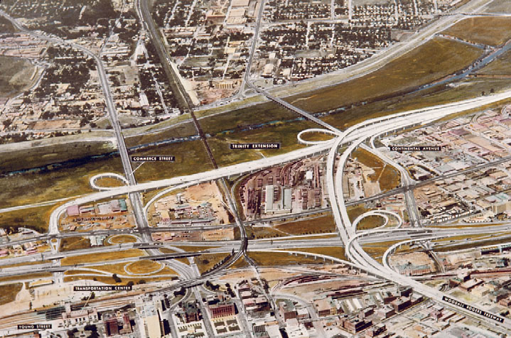
This spring, most North Texas lakes and rivers saw a sudden, sharp surplus in their water levels, and the Trinity River was certainly among them. Areas of Dallas were flooded by the river at the end of May, causing many businesses to close. It also gave several citizens cause for concern over the proposed Trinity Parkway (a toll road which was detailed in an earlier post), and whether or not that road would be flooded by the river. If the toll road is built, it would fulfill the dreams many Dallasites have had for the last fifty years. However, more and more citizens are leaning away from the idea. Perhaps opponents of the new road would be more interested in reviving another transportation dream from the twentieth century: the Trinity Waterway, a proposed canal between Dallas-Fort Worth and the Gulf Coast. The river certainly appears navigable when it is overflowing with water, but it has certainly seen its share of dry spells! The illustration above shows the original plan for the Trinity Parkway. The Trinity River, which once had hopes of becoming navigable, can be seen cutting horizontally through the image.
Although the city worked to get the project underway as far back as the late 1850’s, there was never enough money to get much done. In 1856, the state of Texas supplied $315,000 for improving the river and the land around it, but most of the funds were scooped up by more southern regions, leaving very little for what is now the DFW metroplex. With the outbreak of the Civil War, work on the waterway halted.
While many insisted that it was impossible to get to Dallas from Galveston via river, others were determined to make the journey. In 1893, the H. A. Harvey river boat arrived in Dallas from Galveston after a journey that lasted 2 months and 10 days, reviving interest in building the canal. However, the great flood of 1908, which left over 4,000 people in Dallas homeless, stopped all work on the project again as the city began constructing new levees and aligning the river to protect itself from future floods.
After World War II, federal politicians like Sam Rayburn and Lyndon Johnson backed the idea of the Trinity Waterway, but it remained a proposal until 1965, when a canal between Fort Worth, Dallas, and several new North Texas reservoirs was approved with federal funding. New bridges over the Trinity now required a higher clearance than their predecessors (52 feet) and a span of 300 feet. Because of this, IH 20 in southeast Dallas, IH 45 south of downtown, and Loop 12 in west Dallas have humps in their bridges to accommodate water traffic.
To complete such a grand canal, 15 older bridges in Dallas County, and another 45 on the way to the Gulf, would need to be raised. Rising costs on the project led to a critical vote in 1973 on whether to raise property taxes to help fund the endeavor. The bond proposition was rejected by 56% in Dallas County and 53% in Tarrant County, effectively bringing the Trinity Waterway to its end.
While we have accepted the fact that our transportation in the metroplex is limited by land and air, it’s fun to look at the Trinity and imagine 19th century settlers attempting to navigate the waters. While the river can’t be made as economically useful as we had hoped in the past, we can always enjoy it as an integral aspect of our beautiful North Texas landscape. When we drive over those humped bridges, we can laugh at the idea of barges passing beneath us on their way to Galveston.
More information on changes in DFW’s transportation infrastructure, including the Trinity Turnpike and the Dallas-Fort Worth International Airport, can be found in the Lester Strother and Texas Metro Magazine Collection, as well as the North Central Texas Council of Governments Planning Group Records.
-by Alexandra Traxinger Schütz

Leave a Reply