Remember when your grandmother’s farm was “the brick house with a basset hound out front, about three miles south of the old cemetery?” Now, that farm probably has a real address, something more like 123 Country Road. Beginning in the late 1960’s and throughout the 1970’s, communities began implementing 911 Addressing standards, which meant that buildings needed to have an address with a number and street name. The new guidelines came along with the new emergency phone number, which was quickly adopted by cities across the nation. While most U.S. cities were already following guidelines similar to the 911 standard, more rural areas experienced a larger impact. These postal changes were in addition to the invention of the zip code, which was implemented nationwide in July 1963.

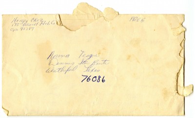
Letter written to Norma Teague, a resident on the Dennis Star Route in Brock, Parker County, Texas. 1968.
In the 19th and early 20th centuries, residents of rural North Texas either had to make a special trek to a far-away post office or pay for a private courier to deliver their mail. To remedy this problem, the U. S. Post Office established a service called Rural Free Delivery (RFD). This system used just the names of recipients, the name of their delivery route, and a box number. For example, my mother lived in the small community of Brock in Parker County as a child, and her letters from the late 1950’s and 1960’s use the address Dennis Star Route, which was sometimes abbreviated to simply DSR.
Now known as highway-contract routes, star routes have been a part of mail delivery in the United States since the 18th century. Rather than having mail delivered by postmen, contractors are hired to deliver the mail on these routes. While there was some decline in their usage in the 1950’s, star route miles more than doubled in the 1960’s, thanks in large part to the Highway Act of 1958.
It wasn’t until after my mother’s family left Brock in the 1970’s that homes and buildings in the area received what we consider now to be a “proper” address. The establishment of 911 addressing had many benefits aside from making mail delivery more efficient. The most obvious one is that emergency responders could get to you quickly and efficiently during a crisis. They don’t have to know where the old cemetery is to find your grandmother anymore! It also made navigating rural areas easier for non-residents.
Throughout the 1970’s, rural North Texas was installing and renewing street signs, updating maps, and affixing numbers to buildings. These developments, along with new highways traversing the region, brought rural areas a little closer (in travel time and design) to urban centers like Dallas and Fort Worth. Of course, trying to find grandmother’s farm on an old country road, even if it is marked, can still be a difficult task to accomplish! But the standardization of addresses certainly has made things easier.
For more insight on how the Southwest Metroplex and surrounding areas, like Parker County, were changing in the 1970’s, take a look at our North Central Texas Council of Governments Planning Group Records collection. Details about special city projects, such as Section 8 housing and community beautification, are detailed within the collection. Gray literature included are handwritten notes, grant applications, maps, and more.
-by Alexandra Traxinger Schütz


Leave a Reply