It’s a bird! It’s a plane! Wait — no, it’s the Eagle Commons Library‘s (ECL) latest addition: a GIS Librarian! My name is Douglas Burns, and I just wanted to give you all a public service announcement that GIS (or, as some people like to call it, geographic information systems) has arrived at ECL.
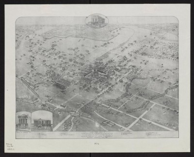
“What is this GIS thing?” you might be asking yourself. Let me explain with a little bit of background first: The UNT Libraries, in partnership with the Geography Department, created a librarian position dedicated to facilitating geographic information, education and research. This position, in turn, supports questions and research with a geographic emphasis. My first project is to create a Historic UNT Webmap illustrating the evolution of UNT’s campus over time to celebrate its 125th Anniversary. Below is a map depicting downtown Denton in 1883, before UNT existed:

To facilitate this project, software such as Esri’s ArcGIS for Desktop will be utilized. ArcGIS for Desktop is a powerful software suite that specializes in the manipulation of geographic information. In today’s ever-changing, fast-paced world, we need a tool that synthesizes data in a variety of forms, puts it in its proper place, analyzes it, and helps make decisions. After all, everything happens somewhere. In the same vein, I recently heard the following observation at a conference: “…we are a GIS-enabled society, but we are not a GIS-literate society,” meaning that it is one thing to find a restaurant for tonight’s date on GoogleMaps versus the ability to leverage geoinformation into a formidable research asset. The more we can understand and visualize those patterns that emerge from the world around us, we can then make better informed (and hopefully better) decisions.
The key thing to keep in mind regarding GIS is that it is a tool for discovery. GIS has applications ranging from combating a forest fire/deforestation, to mapping out the human brain, to making a decision on where to open a new restaurant, to planning a new road or pipeline, to even charting the known universe. Additionally, the Digital Age is still relatively new. Listening to a tech segment on the radio on my drive home last week, I heard a statistic that blew me away: the last two years of human history generated more data than all previous years of recorded human history — combined. Think about that for a moment! While discovery is certainly a priority, grappling with and preserving existing/historic GIS data is also of paramount importance because it chronicles the development of our culture and society in ways parallel to paper maps. The detailed information contained within GIS about present conditions will prove fascinating hundreds of years from now when historians and anthropologists study the Information Age. As libraries house vast amounts of data and are continually generating new information, GIS naturally has one foot in the past and the other in the future. Bridging these disparate applications and goals is where I, the GIS Librarian, come into play. I welcome any questions, ideas or opportunities to collaborate.
With that, I invite you to stop by the Eagle Commons Library to check out what’s happening or simply to say hi.
Article by Douglas Burns.
Map showing Bird’s Eye View of Denton, Denton County, Tex.: 1883 drawn by Augustus Koch.


